A recent initiative will deliver air quality updates every hour across the U.S.
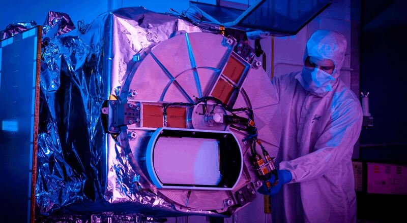
Upon activating the device on a newly launched satellite this season, researchers received an early glimpse into what will become the country’s inaugural ongoing air pollution documentation.
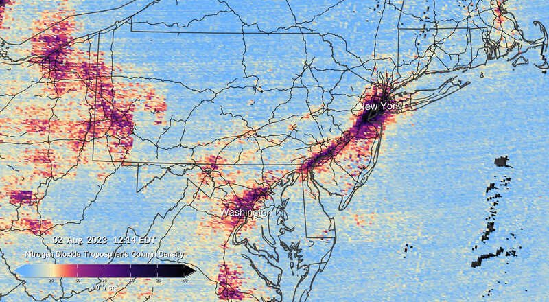
This satellite will remain positioned over North America, offering scientists hourly updates on air pollution during the day. This week, the first set of images was unveiled, illustrating the fluctuations in nitrogen dioxide pollution across the U.S. within 24 hours.

Xiong Liu, the mission’s deputy director and a physicist at the Astrophysics Center operated by Harvard University and the Smithsonian Institution, expressed enthusiasm about the instrument’s performance. Named TEMPO, this satellite tool can also detect various other pollutants.
These visuals emerge during a period of notably poor air quality in the U.S., with wildfire smoke enveloping numerous urban areas. However, even prior to this season, the improvements in air quality that Americans have experienced since the Clean Air Act of 1970 began to stabilize. Dr. Liu highlighted that despite advancements, around “one-third of Americans still experience unhealthy air pollution levels.”
Nitrogen dioxide, a byproduct of fuel combustion, leads to different pollution forms due to aerial chemical reactions. The visuals pinpoint significant concentrations of this gas in major urban areas, especially during peak traffic times in the morning and evening.
Besides satellite observations, scientists embarked on ground and aerial research missions in July and August to comprehend the stagnation in air quality improvement. Given the rapid movement of pollutants with wind currents, pinpointing primary pollution sources has been challenging. However, Brian McDonald, an environmental engineer at the National Oceanic and Atmospheric Administration, believes that TEMPO’s frequent updates will revolutionize researchers’ ability to trace pollution back to its origin.
Historically, vehicular traffic was a major air pollution contributor, but stricter vehicle emission regulations have curtailed this. Concurrently, the significance of consumer goods like paints and pesticides, which release volatile organic compounds, has risen, as explained by Dr. McDonald.
These compounds, when combined with nitrogen dioxide, produce harmful ground-level ozone. This ozone, while protective in the upper atmosphere against UV radiation, can exacerbate respiratory conditions at ground level.
Another concern is fine particulate pollution or PM2.5, which consists of minuscule particles that can infiltrate the bloodstream, leading to heart, lung diseases, and even premature death. After a period of reduction, this pollution type saw an uptick around 2016, with wildfires, intensified by climate change, being the primary reason, as per a study from the previous year.
Marshall Burke, a Stanford University environmental policy professor, emphasized the advantages of having hourly satellite data, likening it to a video that offers a comprehensive pollution overview.
TEMPO’s capabilities extend to tracking pollution with a precision of approximately four square miles. This precision was evident in the coordinated research activities conducted this summer.
Tracey Holloway, an energy analysis and policy professor at the University of Wisconsin-Madison, likened the data from these field studies to a “decoder” for the satellite tool.
In places like New York City, scientists are amassing detailed local data. Most cities, despite monitoring their air, lack the equipment to cover every district, leading to uneven pollution distribution.

Since late July, a team from NOAA, spearheaded by Audrey Gaudel from the University of Colorado Boulder and Prathap Ramamurthy from the City College of New York, have been surveying the city on foot, equipped with air quality sensors. Their data will later be compared with NASA’s aircraft readings, ensuring coverage of areas that often face higher pollution levels but lack adequate data.
Yoshira Ornelas Van Horne, an environmental health professor at Columbia University, anticipates improved pollution prediction models at the street level from this research.
While data analysis will take some months, the fieldwork has already underscored the link between climate change and air quality. On the warmest day of sampling, ozone levels surpassed the standards set by the Environmental Protection Agency, as observed by Dr. Gaudel.
The general public can access TEMPO satellite data by spring 2024. Meanwhile, over 400 entities, including numerous governmental agencies, have registered as “preliminary users.”
Institutions like the Mount Sinai Health System in New York aim to utilize TEMPO data to study the impact of air pollutants on pediatric asthma. The Connecticut Bureau of Air Management intends to determine the origins of the state’s elevated ozone pollution.
Dr. Ornelas Van Horne is optimistic that this year’s research will equip decision-makers with the necessary data to address the persistent air quality issues in the U.S. She emphasized the unanimous consensus on the detrimental effects of air pollution.


